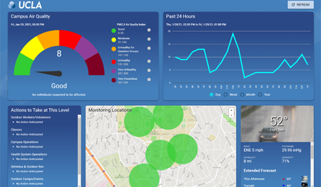
Wildfire events affecting air quality for students, employees and visitors to the UCLA campus will be easier to identify and quicker for campus leadership to respond to thanks to a new interactive Air Quality Index (AQI) webpage developed by Environment, Health & Safety (EH&S) with assistance from the Facilities Management Geographic Information Systems team.
The innovative webpage communicates real-time air quality conditions during wildfire events and enables critical safety decisions to be made quickly in response to the campus environment. The webpage is based on an AQI decision matrix developed by the University of California System-wide Air Quality Protocol Working Group, which supports decision making through a public health and science-based approach and contains both required and recommended actions for each AQI category.
The sensor data are displayed in numerous forms, including AQI color-coded monitoring locations layered on the UCLA campus map, as an aggregate value integrated into an AQI color-coded dial and a data plot of the previous 24 hours, week, month and year.
In addition, the appropriate AQI Decision-Making Matrix ‘Actions to Take at This Level’ are displayed based on the current aggregate AQI. The dashboard can also be configured so any UC campus can display wildfire event air quality data specific to their campus.
The data for UCLA is gathered from five sensors on campus, which were made possible through a collaboration between Administration’s EH&S, Facilities Management, Housing Services and Information Technology Services teams, and UCLA Health.
